


![Trail Walking Le Puy-en-Velay - [01] Compostelle : du Puy-en-Velay à Saint-Privat-d'Allier - Photo](https://media.geolcdn.com/t/1900/400/3a3d9fb8-87a3-471b-89bc-3b15bd06bea3.jpg&format=pjpeg&maxdim=2)
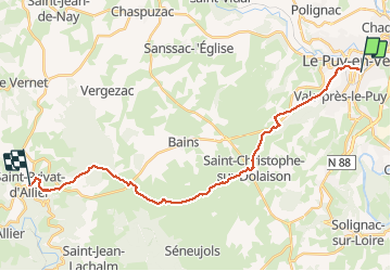
[01] Compostelle : du Puy-en-Velay à Saint-Privat-d'Allier

phimar_2612
User

Length
24 km

Max alt
1215 m

Uphill gradient
669 m
Km-Effort
32 km

Min alt
624 m

Downhill gradient
422 m
Boucle
No
Creation date :
2019-05-21 06:35:14.644
Updated on :
2019-05-24 19:28:26.586
6h28
Difficulty : Difficult

FREE GPS app for hiking
 SityTrail
IGN / Geographical institutes
SityTrail Plus
The world is yours!
About
Trail Walking of 24 km to be discovered at Auvergne-Rhône-Alpes, Haute-Loire, Le Puy-en-Velay. This trail is proposed by phimar_2612.
Photos
![Trail Walking Le Puy-en-Velay - [01] Compostelle : du Puy-en-Velay à Saint-Privat-d'Allier - Photo 1](https://media.geolcdn.com/t/2048/auto/3a3d9fb8-87a3-471b-89bc-3b15bd06bea3.jpg&format=jpg&maxdim=0 "Trail Walking Le Puy-en-Velay - [01] Compostelle : du Puy-en-Velay à Saint-Privat-d'Allier - Photo 1")
![Trail Walking Le Puy-en-Velay - [01] Compostelle : du Puy-en-Velay à Saint-Privat-d'Allier - Photo 2](https://media.geolcdn.com/t/2048/auto/7ea6157f-2bf8-40b6-b114-27355a3d6705.jpg&format=jpg&maxdim=0 "Trail Walking Le Puy-en-Velay - [01] Compostelle : du Puy-en-Velay à Saint-Privat-d'Allier - Photo 2")
![Trail Walking Le Puy-en-Velay - [01] Compostelle : du Puy-en-Velay à Saint-Privat-d'Allier - Photo 3](https://media.geolcdn.com/t/2048/auto/8c9ca115-2ef8-455b-a518-cbc341112d04.jpg&format=jpg&maxdim=0 "Trail Walking Le Puy-en-Velay - [01] Compostelle : du Puy-en-Velay à Saint-Privat-d'Allier - Photo 3")
![Trail Walking Le Puy-en-Velay - [01] Compostelle : du Puy-en-Velay à Saint-Privat-d'Allier - Photo 4](https://media.geolcdn.com/t/2048/auto/bd96345c-1700-44e0-a752-94f36c27f8e0.jpg&format=jpg&maxdim=0 "Trail Walking Le Puy-en-Velay - [01] Compostelle : du Puy-en-Velay à Saint-Privat-d'Allier - Photo 4")
![Trail Walking Le Puy-en-Velay - [01] Compostelle : du Puy-en-Velay à Saint-Privat-d'Allier - Photo 5](https://media.geolcdn.com/t/2048/auto/2d13224e-5bb7-4bd9-969f-29229e8efed4.jpg&format=jpg&maxdim=0 "Trail Walking Le Puy-en-Velay - [01] Compostelle : du Puy-en-Velay à Saint-Privat-d'Allier - Photo 5")
![Trail Walking Le Puy-en-Velay - [01] Compostelle : du Puy-en-Velay à Saint-Privat-d'Allier - Photo 6](https://media.geolcdn.com/t/2048/auto/d91e0056-dcba-45db-a7c0-b510b3d09fb0.jpg&format=jpg&maxdim=0 "Trail Walking Le Puy-en-Velay - [01] Compostelle : du Puy-en-Velay à Saint-Privat-d'Allier - Photo 6")
![Trail Walking Le Puy-en-Velay - [01] Compostelle : du Puy-en-Velay à Saint-Privat-d'Allier - Photo 7](https://media.geolcdn.com/t/2048/auto/493318a8-1f91-4239-8208-d0fcdd3d09ad.jpg&format=jpg&maxdim=0 "Trail Walking Le Puy-en-Velay - [01] Compostelle : du Puy-en-Velay à Saint-Privat-d'Allier - Photo 7")
![Trail Walking Le Puy-en-Velay - [01] Compostelle : du Puy-en-Velay à Saint-Privat-d'Allier - Photo 8](https://media.geolcdn.com/t/2048/auto/bb9ddf01-9b5d-43d6-876c-da89241b6291.jpg&format=jpg&maxdim=0 "Trail Walking Le Puy-en-Velay - [01] Compostelle : du Puy-en-Velay à Saint-Privat-d'Allier - Photo 8")
![Trail Walking Le Puy-en-Velay - [01] Compostelle : du Puy-en-Velay à Saint-Privat-d'Allier - Photo 9](https://media.geolcdn.com/t/2048/auto/4ac267b9-bb04-4026-8231-f0fa4d06eeb4.jpg&format=jpg&maxdim=0 "Trail Walking Le Puy-en-Velay - [01] Compostelle : du Puy-en-Velay à Saint-Privat-d'Allier - Photo 9")
![Trail Walking Le Puy-en-Velay - [01] Compostelle : du Puy-en-Velay à Saint-Privat-d'Allier - Photo 10](https://media.geolcdn.com/t/2048/auto/ebf001d8-1057-4d7c-bcf6-f2777b3ca190.jpg&format=jpg&maxdim=0 "Trail Walking Le Puy-en-Velay - [01] Compostelle : du Puy-en-Velay à Saint-Privat-d'Allier - Photo 10")
![Trail Walking Le Puy-en-Velay - [01] Compostelle : du Puy-en-Velay à Saint-Privat-d'Allier - Photo 11](https://media.geolcdn.com/t/2048/auto/bddda09e-c294-4004-877a-a29fd79998d2.jpg&format=jpg&maxdim=0 "Trail Walking Le Puy-en-Velay - [01] Compostelle : du Puy-en-Velay à Saint-Privat-d'Allier - Photo 11")
![Trail Walking Le Puy-en-Velay - [01] Compostelle : du Puy-en-Velay à Saint-Privat-d'Allier - Photo 12](https://media.geolcdn.com/t/2048/auto/0d3f2ea6-94b7-4481-bedd-713fafd4c5a1.jpg&format=jpg&maxdim=0 "Trail Walking Le Puy-en-Velay - [01] Compostelle : du Puy-en-Velay à Saint-Privat-d'Allier - Photo 12")
![Trail Walking Le Puy-en-Velay - [01] Compostelle : du Puy-en-Velay à Saint-Privat-d'Allier - Photo 13](https://media.geolcdn.com/t/2048/auto/1e2bd599-c3e6-4082-bf93-0580d14b4060.jpg&format=jpg&maxdim=0 "Trail Walking Le Puy-en-Velay - [01] Compostelle : du Puy-en-Velay à Saint-Privat-d'Allier - Photo 13")
![Trail Walking Le Puy-en-Velay - [01] Compostelle : du Puy-en-Velay à Saint-Privat-d'Allier - Photo 14](https://media.geolcdn.com/t/2048/auto/3d75f2cc-c0a7-4947-9978-f47627ad770b.jpg&format=jpg&maxdim=0 "Trail Walking Le Puy-en-Velay - [01] Compostelle : du Puy-en-Velay à Saint-Privat-d'Allier - Photo 14")
![Trail Walking Le Puy-en-Velay - [01] Compostelle : du Puy-en-Velay à Saint-Privat-d'Allier - Photo 15](https://media.geolcdn.com/t/2048/auto/2692510c-4b7f-4f45-a107-fdf4f80fd50b.jpg&format=jpg&maxdim=0 "Trail Walking Le Puy-en-Velay - [01] Compostelle : du Puy-en-Velay à Saint-Privat-d'Allier - Photo 15")
![Trail Walking Le Puy-en-Velay - [01] Compostelle : du Puy-en-Velay à Saint-Privat-d'Allier - Photo 16](https://media.geolcdn.com/t/2048/auto/9797c2da-5543-4c6e-b29e-b38c4d1f59c1.jpg&format=jpg&maxdim=0 "Trail Walking Le Puy-en-Velay - [01] Compostelle : du Puy-en-Velay à Saint-Privat-d'Allier - Photo 16")
![Trail Walking Le Puy-en-Velay - [01] Compostelle : du Puy-en-Velay à Saint-Privat-d'Allier - Photo 17](https://media.geolcdn.com/t/2048/auto/2bfe361b-aeb5-4940-9375-34f15464bd41.jpg&format=jpg&maxdim=0 "Trail Walking Le Puy-en-Velay - [01] Compostelle : du Puy-en-Velay à Saint-Privat-d'Allier - Photo 17")
![Trail Walking Le Puy-en-Velay - [01] Compostelle : du Puy-en-Velay à Saint-Privat-d'Allier - Photo 18](https://media.geolcdn.com/t/2048/auto/404892b7-4889-408e-8e28-dfcbeee54646.jpg&format=jpg&maxdim=0 "Trail Walking Le Puy-en-Velay - [01] Compostelle : du Puy-en-Velay à Saint-Privat-d'Allier - Photo 18")
![Trail Walking Le Puy-en-Velay - [01] Compostelle : du Puy-en-Velay à Saint-Privat-d'Allier - Photo 19](https://media.geolcdn.com/t/2048/auto/f8aca660-a7ad-4b02-b9a1-fc4de249b217.jpg&format=jpg&maxdim=0 "Trail Walking Le Puy-en-Velay - [01] Compostelle : du Puy-en-Velay à Saint-Privat-d'Allier - Photo 19")
![Trail Walking Le Puy-en-Velay - [01] Compostelle : du Puy-en-Velay à Saint-Privat-d'Allier - Photo 20](https://media.geolcdn.com/t/2048/auto/b432d76f-9276-4452-a160-70becc8d89f0.jpg&format=jpg&maxdim=0 "Trail Walking Le Puy-en-Velay - [01] Compostelle : du Puy-en-Velay à Saint-Privat-d'Allier - Photo 20")
![Trail Walking Le Puy-en-Velay - [01] Compostelle : du Puy-en-Velay à Saint-Privat-d'Allier - Photo 21](https://media.geolcdn.com/t/2048/auto/1dfeeac6-085b-452c-b390-7005a9598bbb.jpg&format=jpg&maxdim=0 "Trail Walking Le Puy-en-Velay - [01] Compostelle : du Puy-en-Velay à Saint-Privat-d'Allier - Photo 21")
![Trail Walking Le Puy-en-Velay - [01] Compostelle : du Puy-en-Velay à Saint-Privat-d'Allier - Photo 22](https://media.geolcdn.com/t/2048/auto/3dc17723-93e4-4305-8a44-2d7fda65ba74.jpg&format=jpg&maxdim=0 "Trail Walking Le Puy-en-Velay - [01] Compostelle : du Puy-en-Velay à Saint-Privat-d'Allier - Photo 22")
![Trail Walking Le Puy-en-Velay - [01] Compostelle : du Puy-en-Velay à Saint-Privat-d'Allier - Photo 23](https://media.geolcdn.com/t/2048/auto/cf6cf789-54ff-4e74-9313-07a9290448dc.jpg&format=jpg&maxdim=0 "Trail Walking Le Puy-en-Velay - [01] Compostelle : du Puy-en-Velay à Saint-Privat-d'Allier - Photo 23")
![Trail Walking Le Puy-en-Velay - [01] Compostelle : du Puy-en-Velay à Saint-Privat-d'Allier - Photo 24](https://media.geolcdn.com/t/2048/auto/9fcc5ac2-ce78-419e-8882-c98141d5db1c.jpg&format=jpg&maxdim=0 "Trail Walking Le Puy-en-Velay - [01] Compostelle : du Puy-en-Velay à Saint-Privat-d'Allier - Photo 24")
![Trail Walking Le Puy-en-Velay - [01] Compostelle : du Puy-en-Velay à Saint-Privat-d'Allier - Photo 25](https://media.geolcdn.com/t/2048/auto/b651e85d-f2e8-46db-aca1-3e8c4c1f6b5e.jpg&format=jpg&maxdim=0 "Trail Walking Le Puy-en-Velay - [01] Compostelle : du Puy-en-Velay à Saint-Privat-d'Allier - Photo 25")
![Trail Walking Le Puy-en-Velay - [01] Compostelle : du Puy-en-Velay à Saint-Privat-d'Allier - Photo 26](https://media.geolcdn.com/t/2048/auto/65f445f5-87f3-45f7-b628-a0ddcf40eb0b.jpg&format=jpg&maxdim=0 "Trail Walking Le Puy-en-Velay - [01] Compostelle : du Puy-en-Velay à Saint-Privat-d'Allier - Photo 26")
![Trail Walking Le Puy-en-Velay - [01] Compostelle : du Puy-en-Velay à Saint-Privat-d'Allier - Photo 27](https://media.geolcdn.com/t/2048/auto/8ea46116-7fc1-43d9-83a6-a32b25470152.jpg&format=jpg&maxdim=0 "Trail Walking Le Puy-en-Velay - [01] Compostelle : du Puy-en-Velay à Saint-Privat-d'Allier - Photo 27")
![Trail Walking Le Puy-en-Velay - [01] Compostelle : du Puy-en-Velay à Saint-Privat-d'Allier - Photo 28](https://media.geolcdn.com/t/2048/auto/b84bd79f-23fa-4fca-a468-f84ecae90f04.jpg&format=jpg&maxdim=0 "Trail Walking Le Puy-en-Velay - [01] Compostelle : du Puy-en-Velay à Saint-Privat-d'Allier - Photo 28")
![Trail Walking Le Puy-en-Velay - [01] Compostelle : du Puy-en-Velay à Saint-Privat-d'Allier - Photo 29](https://media.geolcdn.com/t/2048/auto/a2148c1d-ec01-4ceb-83af-345308a38353.jpg&format=jpg&maxdim=0 "Trail Walking Le Puy-en-Velay - [01] Compostelle : du Puy-en-Velay à Saint-Privat-d'Allier - Photo 29")
![Trail Walking Le Puy-en-Velay - [01] Compostelle : du Puy-en-Velay à Saint-Privat-d'Allier - Photo 30](https://media.geolcdn.com/t/2048/auto/d92036e8-cc29-4e32-9ca3-e85686e45e86.jpg&format=jpg&maxdim=0 "Trail Walking Le Puy-en-Velay - [01] Compostelle : du Puy-en-Velay à Saint-Privat-d'Allier - Photo 30")
![Trail Walking Le Puy-en-Velay - [01] Compostelle : du Puy-en-Velay à Saint-Privat-d'Allier - Photo 31](https://media.geolcdn.com/t/2048/auto/202e6d51-4e42-4b5d-ae51-2e828807b849.jpg&format=jpg&maxdim=0 "Trail Walking Le Puy-en-Velay - [01] Compostelle : du Puy-en-Velay à Saint-Privat-d'Allier - Photo 31")
![Trail Walking Le Puy-en-Velay - [01] Compostelle : du Puy-en-Velay à Saint-Privat-d'Allier - Photo 32](https://media.geolcdn.com/t/2048/auto/fc8f3baa-b174-4abb-883f-9b4c8facdfc9.jpg&format=jpg&maxdim=0 "Trail Walking Le Puy-en-Velay - [01] Compostelle : du Puy-en-Velay à Saint-Privat-d'Allier - Photo 32")
32 photos in total. Please click on a photo to see them all in the gallery.
Positioning
Country:
France
Region :
Auvergne-Rhône-Alpes
Department/Province :
Haute-Loire
Municipality :
Le Puy-en-Velay
Location:
Unknown
Start:(Dec)
Start:(UTM)
569958 ; 4987850 (31T) N.
Comments